e-sensing Data Sets
New Data for Agriculture in Mato Grosso
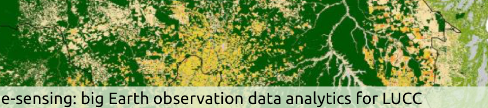
The project team developed innovative methods of using satellite image time series to produce land use and land cover classification for the Mato Grosso state in Brazil from 2001 to 2016 . We used MODIS time series data to classify natural and human-transformed land areas in state of Mato Grosso, Brazil's agricultural frontier. Using the sits R package, we took the full depth of satellite image time series to create large dimensional spaces for statistical classification. Data consists of MODIS MOD13Q1 time series with 23 samples per year per pixel, and 4 bands (NVDI, EVI, NIR and MIR). By taking a series of labelled time series, we used a support vector machine model with a 92-dimensional attribute space. Using a 5-fold cross validation, we obtained an overall accuracy of 94% for discriminating among 9 land cover classes: forest, cerrado, pasture, soybean-fallow, fallow-cotton, soybean-cotton, soybean-corn, soybean-millet and soybean-sunflower. Producer's and user's accuracies of all classes were close to or better than 90%.
The samples for producing the land cover change maps for Mato Grosso State in Brazil from 2001 to 2016, together with the results are available in the PANGAEA repository.
Data Sets on Amazon Web Services
We obtained a grant from Amazon Web Services (AWS) under their "Cloud Credits for Research" program. Using this grant, we have loaded in the AWS cloud servers the following data sets, which are available openly without restrictions.
(a) MODIS MOD09Q1 images at 250-meter resolution from 2000 to 2017 for the whole of the Cerrado biome, with about 6,500 images associated to 150 billion different satellite image time series. This data set is freely available.
(b) Selected LANDSAT images at 30-meter resolution from 2013 to 2015 for the Cerrado biome, with 6,300 images for 15 scenes, producing about 300 billion different satellite image time series. These images are available using the following URLs.
- https://s3-sa-east-1.amazonaws.com/ landsat-wrs-219-075
- https://s3-sa-east-1.awazonaws.com/landsat-wrs-221-065
- https://s3-sa-east-1.awazonaws.com/landsat-wrs-221-068
- https://s3-sa-east-1.awazonaws.com/landsat-wrs-221-069
- https://s3-sa-east-1.awazonaws.com/landsat-wrs-221-070
- https://s3-sa-east-1.awazonaws.com/landsat-wrs-221-086
- https://s3-sa-east-1.awazonaws.com/landsat-wrs-224-062
- https://s3-sa-east-1.awazonaws.com/landsat-wrs-224-063
- https://s3-sa-east-1.awazonaws.com/landsat-wrs-224-073
- https://s3-sa-east-1.awazonaws.com/landsat-wrs-226-064
- https://s3-sa-east-1.awazonaws.com/landsat-wrs-232-066
- https://s3-sa-east-1.awazonaws.com/landsat-wrs-232-067
- https://s3-sa-east-1.awazonaws.com/landsat-wrs-233-067